


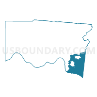
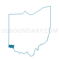
Anderson township, Hamilton County, Ohio
About
Outline

Summary
| Unique Area Identifier | 147049 |
| Name | Anderson township |
| County | Hamilton County |
| State | Ohio |
| Area (square miles) | 31.19 |
| Land Area (square miles) | 30.37 |
| Water Area (square miles) | 0.82 |
| % of Land Area | 97.36 |
| % of Water Area | 2.64 |
| Latitude of the Internal Point | 39.08822030 |
| Longtitude of the Internal Point | -84.35420760 |
| Total Population | 43,446 |
| Total Housing Units | 16,684 |
| Total Households | 15,865 |
| Median Age | 41.2 |
Maps

Graphs
Select a template below for downloading or customizing gragh for Anderson township, Hamilton County, Ohio


Neighbors
Neighoring County Subdivision (by Name) Neighboring County Subdivision on the Map
- Alexandria CCD, Campbell County, KY
- Cincinnati city, Hamilton County, OH
- Columbia township, Hamilton County, OH
- Mariemont village, Hamilton County, OH
- Milford city, Clermont County, OH
- Newport-Fort Thomas CCD, Campbell County, KY
- Newtown village, Hamilton County, OH
- Pierce township, Clermont County, OH
- Terrace Park village, Hamilton County, OH
- Union township, Clermont County, OH
Top 10 Neighboring Place (by Population) Neighboring Place on the Map
- Cincinnati city, OH (296,943)
- Forestville CDP, OH (10,532)
- Dry Run CDP, OH (7,281)
- Withamsville CDP, OH (7,021)
- Milford city, OH (6,709)
- Turpin Hills CDP, OH (5,099)
- Mount Carmel CDP, OH (4,741)
- Cherry Grove CDP, OH (4,378)
- Salem Heights CDP, OH (3,839)
- Fruit Hill CDP, OH (3,755)
Top 10 Neighboring Unified School District (by Population) Neighboring Unified School District on the Map
- Cincinnati City School District, OH (330,202)
- West Clermont Local School District, OH (68,262)
- Forest Hills Local School District, OH (46,156)
- Campbell County School District, KY (41,926)
- Milford Exempted Village School District, OH (41,759)
- New Richmond Exempted Village School District, OH (13,299)
- Mariemont City School District, OH (8,294)
- Silver Grove Independent School District, KY (1,508)
Top 10 Neighboring State Legislative District Lower Chamber (by Population) Neighboring State Legislative District Lower Chamber on the Map
- State House District 66, OH (137,778)
- State House District 35, OH (128,703)
- State House District 88, OH (122,323)
- State House District 34, OH (106,816)
- State House District 68, KY (42,414)
- State House District 78, KY (41,569)
Top 10 Neighboring State Legislative District Upper Chamber (by Population) Neighboring State Legislative District Upper Chamber on the Map
- State Senate District 14, OH (380,921)
- State Senate District 7, OH (378,958)
- State Senate District 24, KY (105,213)
Top 10 Neighboring 111th Congressional District (by Population) Neighboring 111th Congressional District on the Map
Top 10 Neighboring Census Tract (by Population) Neighboring Census Tract on the Map
- Census Tract 412, Clermont County, OH (8,350)
- Census Tract 249.02, Hamilton County, OH (7,858)
- Census Tract 244, Hamilton County, OH (7,524)
- Census Tract 251.02, Hamilton County, OH (7,469)
- Census Tract 250.02, Hamilton County, OH (7,333)
- Census Tract 251.03, Hamilton County, OH (6,712)
- Census Tract 250.01, Hamilton County, OH (6,338)
- Census Tract 415.01, Clermont County, OH (6,269)
- Census Tract 531, Campbell County, KY (5,810)
- Census Tract 529, Campbell County, KY (5,362)
Top 10 Neighboring 5-Digit ZIP Code Tabulation Area (by Population) Neighboring 5-Digit ZIP Code Tabulation Area on the Map
- 45150, OH (31,394)
- 45244, OH (28,565)
- 45230, OH (27,536)
- 45255, OH (21,775)
- 45227, OH (17,486)
- 41076, KY (16,468)
- 45157, OH (9,758)
- 45226, OH (5,476)
- 41059, KY (2,712)
- 45174, OH (2,258)
Data
Demographic, Population, Households, and Housing Units
** Data sources from census 2010 **
Show Data on Map
Download Full List as CSV
Download Quick Sheet as CSV
| Subject | This Area | Hamilton County | Ohio | National |
|---|---|---|---|---|
| POPULATION | ||||
| Total Population Map | 43,446 | 802,374 | 11,536,504 | 308,745,538 |
| POPULATION, HISPANIC OR LATINO ORIGIN | ||||
| Not Hispanic or Latino Map | 42,745 | 781,767 | 11,181,830 | 258,267,944 |
| Hispanic or Latino Map | 701 | 20,607 | 354,674 | 50,477,594 |
| POPULATION, RACE | ||||
| White alone Map | 41,218 | 552,330 | 9,539,437 | 223,553,265 |
| Black or African American alone Map | 494 | 205,952 | 1,407,681 | 38,929,319 |
| American Indian and Alaska Native alone Map | 57 | 1,617 | 25,292 | 2,932,248 |
| Asian alone Map | 855 | 16,182 | 192,233 | 14,674,252 |
| Native Hawaiian and Other Pacific Islander alone Map | 21 | 603 | 4,066 | 540,013 |
| Some Other Race alone Map | 159 | 8,504 | 130,030 | 19,107,368 |
| Two or More Races Map | 642 | 17,186 | 237,765 | 9,009,073 |
| POPULATION, SEX | ||||
| Male Map | 21,041 | 385,221 | 5,632,156 | 151,781,326 |
| Female Map | 22,405 | 417,153 | 5,904,348 | 156,964,212 |
| POPULATION, AGE (18 YEARS) | ||||
| 18 years and over Map | 31,378 | 612,734 | 8,805,753 | 234,564,071 |
| Under 18 years | 12,068 | 189,640 | 2,730,751 | 74,181,467 |
| POPULATION, AGE | ||||
| Under 5 years | 2,604 | 53,269 | 720,856 | 20,201,362 |
| 5 to 9 years | 3,456 | 51,301 | 747,889 | 20,348,657 |
| 10 to 14 years | 3,663 | 51,823 | 774,699 | 20,677,194 |
| 15 to 17 years | 2,345 | 33,247 | 487,307 | 12,954,254 |
| 18 and 19 years | 886 | 24,465 | 336,375 | 9,086,089 |
| 20 years | 290 | 12,078 | 163,986 | 4,519,129 |
| 21 years | 291 | 11,838 | 157,045 | 4,354,294 |
| 22 to 24 years | 1,067 | 35,692 | 442,085 | 12,712,576 |
| 25 to 29 years | 1,710 | 57,995 | 718,630 | 21,101,849 |
| 30 to 34 years | 2,055 | 50,120 | 691,329 | 19,962,099 |
| 35 to 39 years | 2,607 | 47,330 | 718,462 | 20,179,642 |
| 40 to 44 years | 3,183 | 50,516 | 761,369 | 20,890,964 |
| 45 to 49 years | 3,762 | 58,865 | 855,134 | 22,708,591 |
| 50 to 54 years | 3,744 | 61,033 | 887,057 | 22,298,125 |
| 55 to 59 years | 3,211 | 53,500 | 786,857 | 19,664,805 |
| 60 and 61 years | 1,172 | 18,469 | 284,403 | 7,113,727 |
| 62 to 64 years | 1,494 | 23,970 | 381,006 | 9,704,197 |
| 65 and 66 years | 732 | 12,336 | 198,333 | 5,319,902 |
| 67 to 69 years | 1,050 | 17,529 | 280,531 | 7,115,361 |
| 70 to 74 years | 1,260 | 23,465 | 371,370 | 9,278,166 |
| 75 to 79 years | 1,089 | 20,356 | 297,519 | 7,317,795 |
| 80 to 84 years | 827 | 16,791 | 243,833 | 5,743,327 |
| 85 years and over | 948 | 16,386 | 230,429 | 5,493,433 |
| MEDIAN AGE BY SEX | ||||
| Both sexes Map | 41.20 | 37.10 | 38.80 | 37.20 |
| Male Map | 40.00 | 35.30 | 37.40 | 35.80 |
| Female Map | 42.30 | 38.80 | 40.00 | 38.50 |
| HOUSEHOLDS | ||||
| Total Households Map | 15,865 | 333,945 | 4,603,435 | 116,716,292 |
| HOUSEHOLDS, HOUSEHOLD TYPE | ||||
| Family households: Map | 12,175 | 197,571 | 2,991,629 | 77,538,296 |
| Husband-wife family Map | 10,267 | 131,527 | 2,173,477 | 56,510,377 |
| Other family: Map | 1,908 | 66,044 | 818,152 | 21,027,919 |
| Male householder, no wife present Map | 495 | 14,561 | 215,841 | 5,777,570 |
| Female householder, no husband present Map | 1,413 | 51,483 | 602,311 | 15,250,349 |
| Nonfamily households: Map | 3,690 | 136,374 | 1,611,806 | 39,177,996 |
| Householder living alone Map | 3,143 | 113,120 | 1,328,550 | 31,204,909 |
| Householder not living alone Map | 547 | 23,254 | 283,256 | 7,973,087 |
| HOUSEHOLDS, HISPANIC OR LATINO ORIGIN OF HOUSEHOLDER | ||||
| Not Hispanic or Latino householder: Map | 15,689 | 328,073 | 4,505,331 | 103,254,926 |
| Hispanic or Latino householder: Map | 176 | 5,872 | 98,104 | 13,461,366 |
| HOUSEHOLDS, RACE OF HOUSEHOLDER | ||||
| Householder who is White alone | 15,279 | 235,602 | 3,883,694 | 89,754,352 |
| Householder who is Black or African American alone | 160 | 85,325 | 554,094 | 14,129,983 |
| Householder who is American Indian and Alaska Native alone | 21 | 662 | 10,322 | 939,707 |
| Householder who is Asian alone | 253 | 6,068 | 64,713 | 4,632,164 |
| Householder who is Native Hawaiian and Other Pacific Islander alone | 4 | 165 | 1,214 | 143,932 |
| Householder who is Some Other Race alone | 30 | 2,141 | 36,315 | 4,916,427 |
| Householder who is Two or More Races | 118 | 3,982 | 53,083 | 2,199,727 |
| HOUSEHOLDS, HOUSEHOLD TYPE BY HOUSEHOLD SIZE | ||||
| Family households: Map | 12,175 | 197,571 | 2,991,629 | 77,538,296 |
| 2-person household Map | 4,950 | 86,055 | 1,335,123 | 31,882,616 |
| 3-person household Map | 2,622 | 46,779 | 689,256 | 17,765,829 |
| 4-person household Map | 2,820 | 36,760 | 562,136 | 15,214,075 |
| 5-person household Map | 1,235 | 17,566 | 257,799 | 7,411,997 |
| 6-person household Map | 391 | 6,593 | 94,221 | 3,026,278 |
| 7-or-more-person household Map | 157 | 3,818 | 53,094 | 2,237,501 |
| Nonfamily households: Map | 3,690 | 136,374 | 1,611,806 | 39,177,996 |
| 1-person household Map | 3,143 | 113,120 | 1,328,550 | 31,204,909 |
| 2-person household Map | 470 | 19,194 | 232,967 | 6,360,012 |
| 3-person household Map | 52 | 2,454 | 30,878 | 992,156 |
| 4-person household Map | 17 | 997 | 12,876 | 411,171 |
| 5-person household Map | 6 | 385 | 4,208 | 126,634 |
| 6-person household Map | 2 | 144 | 1,378 | 48,421 |
| 7-or-more-person household Map | 0 | 80 | 949 | 34,693 |
| HOUSING UNITS | ||||
| Total Housing Units Map | 16,684 | 377,364 | 5,127,508 | 131,704,730 |
| HOUSING UNITS, OCCUPANCY STATUS | ||||
| Occupied Map | 15,865 | 333,945 | 4,603,435 | 116,716,292 |
| Vacant Map | 819 | 43,419 | 524,073 | 14,988,438 |
| HOUSING UNITS, OCCUPIED, TENURE | ||||
| Owned with a mortgage or a loan Map | 10,571 | 148,805 | 2,176,481 | 52,979,430 |
| Owned free and clear Map | 3,131 | 49,945 | 934,573 | 23,006,644 |
| Renter occupied Map | 2,163 | 135,195 | 1,492,381 | 40,730,218 |
| HOUSING UNITS, VACANT, VACANCY STATUS | ||||
| For rent Map | 202 | 20,210 | 184,143 | 4,137,567 |
| Rented, not occupied Map | 14 | 731 | 8,126 | 206,825 |
| For sale only Map | 206 | 6,162 | 78,089 | 1,896,796 |
| Sold, not occupied Map | 43 | 1,545 | 19,263 | 421,032 |
| For seasonal, recreational, or occasional use Map | 171 | 1,680 | 58,591 | 4,649,298 |
| For migrant workers Map | 0 | 13 | 346 | 24,161 |
| Other vacant Map | 183 | 13,078 | 175,515 | 3,652,759 |
| HOUSING UNITS, OCCUPIED, AVERAGE HOUSEHOLD SIZE BY TENURE | ||||
| Total: Map | 2.72 | 2.34 | 2.44 | 2.58 |
| Owner occupied Map | 2.80 | 2.51 | 2.54 | 2.65 |
| Renter occupied Map | 2.18 | 2.11 | 2.24 | 2.44 |
| HOUSING UNITS, OCCUPIED, TENURE BY RACE OF HOUSEHOLDER | ||||
| Owner occupied: Map | 13,702 | 198,750 | 3,111,054 | 75,986,074 |
| Householder who is White alone Map | 13,262 | 165,251 | 2,819,180 | 63,446,275 |
| Householder who is Black or African American alone Map | 88 | 28,376 | 213,788 | 6,261,464 |
| Householder who is American Indian and Alaska Native alone Map | 15 | 269 | 5,284 | 509,588 |
| Householder who is Asian alone Map | 229 | 2,767 | 35,173 | 2,688,861 |
| Householder who is Native Hawaiian and Other Pacific Islander alone Map | 3 | 42 | 483 | 61,911 |
| Householder who is Some Other Race alone Map | 16 | 518 | 13,283 | 1,975,817 |
| Householder who is Two or More Races Map | 89 | 1,527 | 23,863 | 1,042,158 |
| Renter occupied: Map | 2,163 | 135,195 | 1,492,381 | 40,730,218 |
| Householder who is White alone Map | 2,017 | 70,351 | 1,064,514 | 26,308,077 |
| Householder who is Black or African American alone Map | 72 | 56,949 | 340,306 | 7,868,519 |
| Householder who is American Indian and Alaska Native alone Map | 6 | 393 | 5,038 | 430,119 |
| Householder who is Asian alone Map | 24 | 3,301 | 29,540 | 1,943,303 |
| Householder who is Native Hawaiian and Other Pacific Islander alone Map | 1 | 123 | 731 | 82,021 |
| Householder who is Some Other Race alone Map | 14 | 1,623 | 23,032 | 2,940,610 |
| Householder who is Two or More Races Map | 29 | 2,455 | 29,220 | 1,157,569 |
| HOUSING UNITS, OCCUPIED, TENURE BY HISPANIC OR LATINO ORIGIN OF HOUSEHOLDER | ||||
| Owner occupied: Map | 13,702 | 198,750 | 3,111,054 | 75,986,074 |
| Not Hispanic or Latino householder Map | 13,571 | 196,722 | 3,067,502 | 69,617,625 |
| Hispanic or Latino householder Map | 131 | 2,028 | 43,552 | 6,368,449 |
| Renter occupied: Map | 2,163 | 135,195 | 1,492,381 | 40,730,218 |
| Not Hispanic or Latino householder Map | 2,118 | 131,351 | 1,437,829 | 33,637,301 |
| Hispanic or Latino householder Map | 45 | 3,844 | 54,552 | 7,092,917 |
| HOUSING UNITS, OCCUPIED, TENURE BY HOUSEHOLD SIZE | ||||
| Owner occupied: Map | 13,702 | 198,750 | 3,111,054 | 75,986,074 |
| 1-person household Map | 2,211 | 50,012 | 712,604 | 16,453,569 |
| 2-person household Map | 4,859 | 71,769 | 1,181,472 | 27,618,605 |
| 3-person household Map | 2,403 | 31,682 | 502,915 | 12,517,563 |
| 4-person household Map | 2,597 | 26,700 | 427,146 | 10,998,793 |
| 5-person household Map | 1,141 | 12,207 | 187,245 | 5,057,765 |
| 6-person household Map | 349 | 4,302 | 65,128 | 1,965,796 |
| 7-or-more-person household Map | 142 | 2,078 | 34,544 | 1,373,983 |
| Renter occupied: Map | 2,163 | 135,195 | 1,492,381 | 40,730,218 |
| 1-person household Map | 932 | 63,108 | 615,946 | 14,751,340 |
| 2-person household Map | 561 | 33,480 | 386,618 | 10,624,023 |
| 3-person household Map | 271 | 17,551 | 217,219 | 6,240,422 |
| 4-person household Map | 240 | 11,057 | 147,866 | 4,626,453 |
| 5-person household Map | 100 | 5,744 | 74,762 | 2,480,866 |
| 6-person household Map | 44 | 2,435 | 30,471 | 1,108,903 |
| 7-or-more-person household Map | 15 | 1,820 | 19,499 | 898,211 |
Loading...