


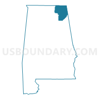
DeKalb & Jackson Counties PUMA, Alabama
About
Outline

Summary
| Unique Area Identifier | 192084 |
| Name | DeKalb & Jackson Counties PUMA |
| State | Alabama |
| Area (square miles) | 1,905.46 |
| Land Area (square miles) | 1,854.96 |
| Water Area (square miles) | 50.49 |
| % of Land Area | 97.35 |
| % of Water Area | 2.65 |
| Latitude of the Internal Point | 34.64449420 |
| Longtitude of the Internal Point | -85.90620410 |
Maps

Graphs
Select a template below for downloading or customizing gragh for DeKalb & Jackson Counties PUMA, Alabama


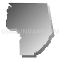


Neighbors
Neighoring Public Use Microdata Area (by Name) Neighboring Public Use Microdata Area on the Map
- Coffee, Franklin, Lincoln & Moore Counties PUMA, TN
- Etowah County PUMA, AL
- Limestone & Madison (Outer) Counties--Huntsville City (Far West & Southwest) PUMA, AL
- Marshall & Madison (Southeast) Counties--Huntsville City (Far Southeast) PUMA, AL
- Northwest Georgia Regional Commission--Walker, Catoosa, Chattooga & Dade Counties PUMA, GA
- Rhea, Marion, Sequatchie, Grundy, Bledsoe & Meigs Counties PUMA, TN
- Talladega, Cherokee, Randolph, Cleburne & Clay Counties PUMA, AL
Top 10 Neighboring County (by Population) Neighboring County on the Map
- Madison County, AL (334,811)
- Etowah County, AL (104,430)
- Marshall County, AL (93,019)
- DeKalb County, AL (71,109)
- Walker County, GA (68,756)
- Jackson County, AL (53,227)
- Franklin County, TN (41,052)
- Marion County, TN (28,237)
- Chattooga County, GA (26,015)
- Cherokee County, AL (25,989)
Top 10 Neighboring County Subdivision (by Population) Neighboring County Subdivision on the Map
- Albertville-Boaz CCD, Marshall County, AL (37,950)
- Scottsboro CCD, Jackson County, AL (19,895)
- Fort Payne CCD, DeKalb County, AL (19,055)
- Gurley CCD, Madison County, AL (15,745)
- New Market CCD, Madison County, AL (14,871)
- New Hope CCD, Madison County, AL (13,968)
- Rainsville-Sylvania CCD, DeKalb County, AL (13,391)
- Grant CCD, Marshall County, AL (10,201)
- Mountainboro CCD, Etowah County, AL (9,378)
- Crossville CCD, DeKalb County, AL (8,628)
Top 10 Neighboring Place (by Population) Neighboring Place on the Map
- Scottsboro city, AL (14,770)
- Fort Payne city, AL (14,012)
- Boaz city, AL (9,551)
- Rainsville city, AL (4,948)
- South Pittsburg city, TN (2,992)
- Bridgeport city, AL (2,418)
- Henagar city, AL (2,344)
- Whitesboro CDP, AL (2,138)
- Stevenson city, AL (2,046)
- Collinsville town, AL (1,983)
Top 10 Neighboring Unified School District (by Population) Neighboring Unified School District on the Map
- Madison County School District, AL (123,029)
- Walker County School District, GA (65,673)
- Etowah County School District, AL (60,417)
- DeKalb County School District, AL (57,097)
- Marshall County School District, AL (47,197)
- Franklin County School District, TN (41,052)
- Jackson County School District, AL (38,458)
- Marion County School District, TN (27,274)
- Cherokee County School District, AL (25,989)
- Chattooga County School District, GA (24,188)
Top 10 Neighboring State Legislative District Lower Chamber (by Population) Neighboring State Legislative District Lower Chamber on the Map
- State House District 37, TN (61,600)
- State House District 39, TN (60,823)
- State House District 26, AL (52,448)
- State House District 2, GA (49,475)
- State House District 22, AL (48,959)
- State House District 24, AL (48,127)
- State House District 11, GA (47,447)
- State House District 27, AL (47,288)
- State House District 39, AL (46,905)
- State House District 29, AL (43,353)
Top 10 Neighboring State Legislative District Upper Chamber (by Population) Neighboring State Legislative District Upper Chamber on the Map
- State Senate District 14, TN (179,926)
- State Senate District 10, TN (176,153)
- State Senate District 53, GA (164,710)
- State Senate District 9, AL (144,554)
- State Senate District 8, AL (142,128)
- State Senate District 10, AL (125,075)
Top 10 Neighboring 111th Congressional District (by Population) Neighboring 111th Congressional District on the Map
- Congressional District 9, GA (823,583)
- Congressional District 11, GA (794,969)
- Congressional District 5, AL (718,724)
- Congressional District 4, TN (688,008)
- Congressional District 3, AL (681,298)
- Congressional District 4, AL (660,162)
Top 10 Neighboring Census Tract (by Population) Neighboring Census Tract on the Map
- Census Tract 101, Madison County, AL (9,355)
- Census Tract 9607, DeKalb County, AL (8,628)
- Census Tract 308.02, Marshall County, AL (7,726)
- Census Tract 9511, Jackson County, AL (7,095)
- Census Tract 9603, DeKalb County, AL (6,908)
- Census Tract 9501, Jackson County, AL (6,749)
- Census Tract 9604, DeKalb County, AL (6,483)
- Census Tract 9606, DeKalb County, AL (6,393)
- Census Tract 9613, DeKalb County, AL (5,967)
- Census Tract 9506, Jackson County, AL (5,951)
Top 10 Neighboring 5-Digit ZIP Code Tabulation Area (by Population) Neighboring 5-Digit ZIP Code Tabulation Area on the Map
- 35967, AL (16,630)
- 35957, AL (15,693)
- 35951, AL (13,098)
- 35954, AL (12,416)
- 35761, AL (11,630)
- 35768, AL (11,581)
- 30752, GA (9,800)
- 35769, AL (9,537)
- 35956, AL (8,842)
- 35962, AL (8,300)