


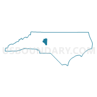
Davidson County PUMA, North Carolina
About
Outline

Summary
| Unique Area Identifier | 193660 |
| Name | Davidson County PUMA |
| State | North Carolina |
| Area (square miles) | 567.02 |
| Land Area (square miles) | 552.67 |
| Water Area (square miles) | 14.34 |
| % of Land Area | 97.47 |
| % of Water Area | 2.53 |
| Latitude of the Internal Point | 35.79512250 |
| Longtitude of the Internal Point | -80.20652470 |
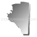
Maps

Graphs
Select a template below for downloading or customizing gragh for Davidson County PUMA, North Carolina


Neighbors
Neighoring Public Use Microdata Area (by Name) Neighboring Public Use Microdata Area on the Map
- Davie, Yadkin & Iredell (North) Counties PUMA, NC
- Forsyth County (Outside Winston-Salem City)--Kernersville Town & Clemmons Village PUMA, NC
- Guilford County (South)--High Point City PUMA, NC
- Moore & Montgomery Counties PUMA, NC
- Randolph County PUMA, NC
- Rowan County PUMA, NC
- Stanley & Cabarrus (East) Counties PUMA, NC
- Winston-Salem City (South) PUMA, NC
Top 10 Neighboring County (by Population) Neighboring County on the Map
- Guilford County, NC (488,406)
- Forsyth County, NC (350,670)
- Davidson County, NC (162,878)
- Randolph County, NC (141,752)
- Rowan County, NC (138,428)
- Stanly County, NC (60,585)
- Davie County, NC (41,240)
- Montgomery County, NC (27,798)
Top 10 Neighboring County Subdivision (by Population) Neighboring County Subdivision on the Map
- Winston township, Forsyth County, NC (229,617)
- High Point township, Guilford County, NC (79,032)
- Thomasville township, Davidson County, NC (39,010)
- Lexington township, Davidson County, NC (30,851)
- Salisbury township, Rowan County, NC (28,205)
- Trinity township, Randolph County, NC (26,604)
- Clemmonsville township, Forsyth County, NC (14,927)
- Abbotts Creek township, Davidson County, NC (12,846)
- Franklin township, Rowan County, NC (12,322)
- Midway township, Davidson County, NC (12,181)
Top 10 Neighboring Place (by Population) Neighboring Place on the Map
- Winston-Salem city, NC (229,617)
- High Point city, NC (104,371)
- Thomasville city, NC (26,757)
- Lexington city, NC (18,931)
- Trinity city, NC (6,614)
- Midway town, NC (4,679)
- Welcome CDP, NC (4,162)
- Tyro CDP, NC (3,879)
- Wallburg town, NC (3,047)
- Denton town, NC (1,636)
Top 10 Neighboring Unified School District (by Population) Neighboring Unified School District on the Map
- Guilford County Schools, NC (488,406)
- Forsyth County Schools, NC (350,670)
- Rowan-Salisbury Schools, NC (130,380)
- Davidson County Schools, NC (127,662)
- Randolph County Schools, NC (113,222)
- Stanly County Schools, NC (60,585)
- Davie County Schools, NC (41,240)
- Montgomery County Schools, NC (27,798)
- Lexington City Schools, NC (20,237)
- Thomasville City Schools, NC (14,979)
Top 10 Neighboring State Legislative District Lower Chamber (by Population) Neighboring State Legislative District Lower Chamber on the Map
- State House District 61, NC (87,087)
- State House District 73, NC (82,874)
- State House District 75, NC (82,603)
- State House District 80, NC (78,723)
- State House District 67, NC (75,179)
- State House District 79, NC (74,556)
- State House District 76, NC (71,116)
- State House District 78, NC (69,360)
- State House District 77, NC (67,312)
- State House District 81, NC (65,650)
Top 10 Neighboring State Legislative District Upper Chamber (by Population) Neighboring State Legislative District Upper Chamber on the Map
- State Senate District 33, NC (189,009)
- State Senate District 34, NC (179,668)
- State Senate District 28, NC (177,037)
- State Senate District 32, NC (175,441)
- State Senate District 31, NC (175,229)
- State Senate District 25, NC (170,329)
- State Senate District 29, NC (169,550)
Top 10 Neighboring 111th Congressional District (by Population) Neighboring 111th Congressional District on the Map
- Congressional District 12, NC (736,346)
- Congressional District 6, NC (714,412)
- Congressional District 8, NC (709,449)
- Congressional District 5, NC (693,414)
Top 10 Neighboring Census Tract (by Population) Neighboring Census Tract on the Map
- Census Tract 601.02, Davidson County, NC (7,213)
- Census Tract 611, Davidson County, NC (6,744)
- Census Tract 618.02, Davidson County, NC (6,740)
- Census Tract 617.02, Davidson County, NC (6,730)
- Census Tract 35, Forsyth County, NC (6,562)
- Census Tract 618.04, Davidson County, NC (6,536)
- Census Tract 807, Davie County, NC (6,393)
- Census Tract 619.01, Davidson County, NC (6,301)
- Census Tract 615, Davidson County, NC (6,214)
- Census Tract 315.01, Randolph County, NC (6,079)
Top 10 Neighboring 5-Digit ZIP Code Tabulation Area (by Population) Neighboring 5-Digit ZIP Code Tabulation Area on the Map
- 27284, NC (51,136)
- 27107, NC (46,963)
- 27265, NC (46,690)
- 27360, NC (46,084)
- 27292, NC (39,787)
- 27295, NC (37,211)
- 27127, NC (34,138)
- 28146, NC (27,614)
- 27028, NC (25,839)
- 27012, NC (25,461)