


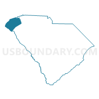
Pickens & Oconee Counties--Easley & Clemson Cities PUMA, South Carolina
About
Outline

Summary
| Unique Area Identifier | 193941 |
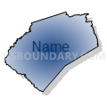
| Name | Pickens & Oconee Counties--Easley & Clemson Cities PUMA |
| State | South Carolina |
| Area (square miles) | 1,185.54 |
| Land Area (square miles) | 1,122.74 |
| Water Area (square miles) | 62.80 |
| % of Land Area | 94.70 |
| % of Water Area | 5.30 |
| Latitude of the Internal Point | 34.81127430 |
| Longtitude of the Internal Point | -82.91831810 |
Maps

Graphs
Select a template below for downloading or customizing gragh for Pickens & Oconee Counties--Easley & Clemson Cities PUMA, South Carolina


Neighbors
Neighoring Public Use Microdata Area (by Name) Neighboring Public Use Microdata Area on the Map
- Anderson County--Anderson City PUMA, SC
- Georgia Mountains Regional Commission (North & Northwest) PUMA, GA
- Georgia Mountains Regional Commission (Southeast) PUMA, GA
- Greenville County (North Central & Outside Greenville City)--Wade Hampton & Berea PUMA, SC
- Greenville County (North)--Greer City (North & West) & Taylors (Central & East) PUMA, SC
- Henderson & Transylvania Counties PUMA, NC
- Jackson (South), Macon, Cherokee & Clay Counties PUMA, NC
Top 10 Neighboring County (by Population) Neighboring County on the Map
- Greenville County, SC (451,225)
- Anderson County, SC (187,126)
- Pickens County, SC (119,224)
- Oconee County, SC (74,273)
- Habersham County, GA (43,041)
- Jackson County, NC (40,271)
- Macon County, NC (33,922)
- Transylvania County, NC (33,090)
- Stephens County, GA (26,175)
- Hart County, GA (25,213)
Top 10 Neighboring County Subdivision (by Population) Neighboring County Subdivision on the Map
- Greenville CCD, Greenville County, SC (263,637)
- Easley CCD, Pickens County, SC (37,074)
- Powdersville-Piedmont CCD, Anderson County, SC (26,414)
- Seneca CCD, Oconee County, SC (25,923)
- Clemson CCD, Pickens County, SC (19,753)
- Walhalla CCD, Oconee County, SC (19,288)
- Pendleton CCD, Anderson County, SC (17,948)
- Pickens CCD, Pickens County, SC (15,711)
- Travelers Rest CCD, Greenville County, SC (14,055)
- Toccoa CCD, Stephens County, GA (13,524)
Top 10 Neighboring Place (by Population) Neighboring Place on the Map
- Easley city, SC (19,993)
- Berea CDP, SC (14,295)
- Clemson city, SC (13,905)
- Parker CDP, SC (11,431)
- Seneca city, SC (8,102)
- Powdersville CDP, SC (7,618)
- Welcome CDP, SC (6,668)
- Central town, SC (5,159)
- Walhalla city, SC (4,263)
- Liberty city, SC (3,269)
Top 10 Neighboring Unified School District (by Population) Neighboring Unified School District on the Map
- Greenville County School District, SC (466,178)
- Pickens County School District, SC (119,224)
- Oconee County School District, SC (74,273)
- Anderson School District 1, SC (49,808)
- Habersham County School District, GA (43,041)
- Jackson County Schools, NC (36,627)
- Macon County Schools, NC (33,922)
- Transylvania County Schools, NC (33,090)
- Stephens County School District, GA (26,175)
- Hart County School District, GA (25,213)
Top 10 Neighboring State Legislative District Lower Chamber (by Population) Neighboring State Legislative District Lower Chamber on the Map
- State House District 113, NC (75,113)
- State House District 119, NC (73,640)
- State House District 120, NC (72,565)
- State House District 10, GA (56,695)
- State House District 8, GA (53,313)
- State House District 28, GA (50,491)
- State House District 29, GA (49,432)
- State House District 10, SC (40,461)
- State House District 2, SC (37,913)
- State House District 17, SC (37,353)
Top 10 Neighboring State Legislative District Upper Chamber (by Population) Neighboring State Legislative District Upper Chamber on the Map
- State Senate District 50, NC (175,858)
- State Senate District 50, GA (164,656)
- State Senate District 5, SC (115,205)
- State Senate District 3, SC (109,541)
- State Senate District 2, SC (97,675)
- State Senate District 6, SC (96,304)
- State Senate District 1, SC (95,822)
- State Senate District 7, SC (83,871)
Top 10 Neighboring 111th Congressional District (by Population) Neighboring 111th Congressional District on the Map
- Congressional District 4, SC (770,226)
- Congressional District 10, GA (738,248)
- Congressional District 3, SC (722,675)
- Congressional District 11, NC (703,606)
Top 10 Neighboring Census Tract (by Population) Neighboring Census Tract on the Map
- Census Tract 101.04, Anderson County, SC (7,915)
- Census Tract 309.02, Oconee County, SC (7,526)
- Census Tract 106, Anderson County, SC (7,409)
- Census Tract 111.02, Pickens County, SC (7,342)
- Census Tract 101.03, Anderson County, SC (7,244)
- Census Tract 308, Oconee County, SC (7,214)
- Census Tract 304.01, Oconee County, SC (6,989)
- Census Tract 106.02, Pickens County, SC (6,971)
- Census Tract 9701, Stephens County, GA (6,923)
- Census Tract 110.02, Pickens County, SC (6,469)
Top 10 Neighboring 5-Digit ZIP Code Tabulation Area (by Population) Neighboring 5-Digit ZIP Code Tabulation Area on the Map
- 29640, SC (30,574)
- 29642, SC (29,561)
- 29611, SC (28,799)
- 29625, SC (27,538)
- 29617, SC (25,685)
- 30577, GA (22,230)
- 29678, SC (21,676)
- 29690, SC (20,914)
- 28712, NC (19,347)
- 29671, SC (18,030)