


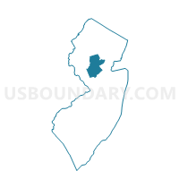
Hillsborough township voting district 20, Somerset County, New Jersey
About
Outline

Summary
| Unique Area Identifier | 622076 |
| Name | Hillsborough township voting district 20 |
| County | Somerset County |
| State | New Jersey |
| Area (square miles) | 0.64 |
| Land Area (square miles) | 0.64 |
| Water Area (square miles) | 0.00 |
| % of Land Area | 100.00 |
| % of Water Area | 0.00 |
| Latitude of the Internal Point | 40.46452680 |
| Longtitude of the Internal Point | -74.60274440 |
Maps


Graphs
Select a template below for downloading or customizing gragh for Hillsborough township voting district 20, Somerset County, New Jersey


Neighbors
Neighoring Voting District (by Name) Neighboring Voting District on the Map
- Hillsborough township voting district 11, Somerset County, NJ
- Hillsborough township voting district 18, Somerset County, NJ
- Hillsborough township voting district 22, Somerset County, NJ
- Hillsborough township voting district 27, Somerset County, NJ
- Montgomery township voting district 12, Somerset County, NJ
Top 10 Neighboring County Subdivision (by Population) Neighboring County Subdivision on the Map
- Hillsborough township, Somerset County, NJ (38,303)
- Montgomery township, Somerset County, NJ (22,254)