


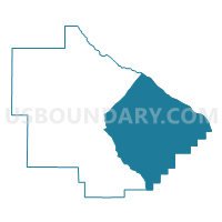
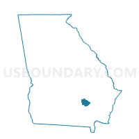
0005NEWL - NEW LACY Voting District, Bacon County, Georgia
About
Outline

Summary
| Unique Area Identifier | 560245 |
| Name | 0005NEWL - NEW LACY Voting District |
| County | Bacon County |
| State | Georgia |
| Area (square miles) | 91.34 |
| Land Area (square miles) | 84.59 |
| Water Area (square miles) | 6.75 |
| % of Land Area | 92.61 |
| % of Water Area | 7.39 |
| Latitude of the Internal Point | 31.53301830 |
| Longtitude of the Internal Point | -82.34246490 |
Maps

Graphs
Select a template below for downloading or customizing gragh for 0005NEWL - NEW LACY Voting District, Bacon County, Georgia


Neighbors
Neighoring Voting District (by Name) Neighboring Voting District on the Map
- 0014B - 4B Voting District, Appling County, GA
- 0014C - 4C Voting District, Appling County, GA
- 005DOUGL - DOUGLAS Voting District, Bacon County, GA
- 005WARE - WARE Voting District, Bacon County, GA
- 005WARNO - WARNOCK Voting District, Bacon County, GA
- 2294B - MERSHON Voting District, Pierce County, GA
- 2294C - ALABAHA Voting District, Pierce County, GA
- 2294D - SUNSET/SWEAT Voting District, Pierce County, GA
Top 10 Neighboring County Subdivision (by Population) Neighboring County Subdivision on the Map
- Blackshear CCD, Pierce County, GA (14,173)
- Alma CCD, Bacon County, GA (8,039)
- Big Satilla Creek CCD, Appling County, GA (3,864)
- Rockingham CCD, Bacon County, GA (3,057)
- Bristol CCD, Pierce County, GA (1,683)
- Surrency-Troper CCD, Appling County, GA (1,476)
Top 10 Neighboring Place (by Population) Neighboring Place on the Map
Top 10 Neighboring Unified School District (by Population) Neighboring Unified School District on the Map
- Pierce County School District, GA (18,758)
- Appling County School District, GA (18,236)
- Bacon County School District, GA (11,096)
Top 10 Neighboring State Legislative District Lower Chamber (by Population) Neighboring State Legislative District Lower Chamber on the Map
Top 10 Neighboring State Legislative District Upper Chamber (by Population) Neighboring State Legislative District Upper Chamber on the Map
Top 10 Neighboring 111th Congressional District (by Population) Neighboring 111th Congressional District on the Map
Top 10 Neighboring Census Tract (by Population) Neighboring Census Tract on the Map
- Census Tract 9603, Pierce County, GA (6,370)
- Census Tract 9505, Appling County, GA (3,864)
- Census Tract 9702.02, Bacon County, GA (3,806)
- Census Tract 9701, Bacon County, GA (3,057)
- Census Tract 9602, Pierce County, GA (1,688)
- Census Tract 9504, Appling County, GA (1,476)