


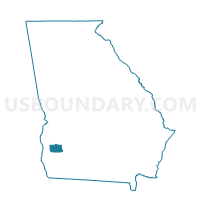
0371 - LEARY Voting District, Calhoun County, Georgia
About
Outline

Summary
| Unique Area Identifier | 560434 |
| Name | 0371 - LEARY Voting District |
| County | Calhoun County |
| State | Georgia |
| Area (square miles) | 98.52 |
| Land Area (square miles) | 97.25 |
| Water Area (square miles) | 1.28 |
| % of Land Area | 98.70 |
| % of Water Area | 1.30 |
| Latitude of the Internal Point | 31.51696710 |
| Longtitude of the Internal Point | -84.50682440 |
Maps


Graphs
Select a template below for downloading or customizing gragh for 0371 - LEARY Voting District, Calhoun County, Georgia


Neighbors
Neighoring Voting District (by Name) Neighboring Voting District on the Map
- 007E - ELMODEL Voting District, Baker County, GA
- 007M - MILFORD Voting District, Baker County, GA
- 007N - NEWTON Voting District, Baker County, GA
- 0372 - MORGAN Voting District, Calhoun County, GA
- 09510 - SECOND MT ZION Voting District, Dougherty County, GA
- 09528 - CHRIST CHURCH Voting District, Dougherty County, GA
- 243998 - 4TH DISTRICT Voting District, Randolph County, GA
- 27302 - SASSER Voting District, Terrell County, GA
- 27306 - HEROD-DOVER Voting District, Terrell County, GA
Top 10 Neighboring County Subdivision (by Population) Neighboring County Subdivision on the Map
- West Dougherty CCD, Dougherty County, GA (61,435)
- Dawson CCD, Terrell County, GA (6,381)
- Morgan CCD, Calhoun County, GA (2,287)
- Newton CCD, Baker County, GA (2,198)
- Shellman CCD, Randolph County, GA (1,582)
- Sasser CCD, Terrell County, GA (1,407)
- Milford CCD, Baker County, GA (1,253)
- Leary CCD, Calhoun County, GA (876)
Top 10 Neighboring Place (by Population) Neighboring Place on the Map
Top 10 Neighboring Unified School District (by Population) Neighboring Unified School District on the Map
- Dougherty School District, GA (94,565)
- Terrell County School District, GA (9,315)
- Randolph County School District, GA (7,719)
- Calhoun County School District, GA (6,694)
- Baker County School District, GA (3,451)
Top 10 Neighboring State Legislative District Lower Chamber (by Population) Neighboring State Legislative District Lower Chamber on the Map
- State House District 150, GA (45,353)
- State House District 149, GA (43,458)
- State House District 148, GA (41,718)
Top 10 Neighboring State Legislative District Upper Chamber (by Population) Neighboring State Legislative District Upper Chamber on the Map
Top 10 Neighboring 111th Congressional District (by Population) Neighboring 111th Congressional District on the Map
Top 10 Neighboring Census Tract (by Population) Neighboring Census Tract on the Map
- Census Tract 9501, Calhoun County, GA (3,163)
- Census Tract 1204, Terrell County, GA (3,137)
- Census Tract 9601, Baker County, GA (2,198)
- Census Tract 7901, Randolph County, GA (1,898)
- Census Tract 104.03, Dougherty County, GA (1,708)
- Census Tract 1205, Terrell County, GA (1,407)
- Census Tract 9602, Baker County, GA (1,253)
Top 10 Neighboring 5-Digit ZIP Code Tabulation Area (by Population) Neighboring 5-Digit ZIP Code Tabulation Area on the Map
- 31721, GA (20,095)
- 39842, GA (8,357)
- 39870, GA (2,238)
- 39866, GA (2,122)
- 39886, GA (1,616)
- 39862, GA (1,326)