


Doniphan Precinct, Hall County, Nebraska
About
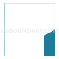
Outline

Summary
| Unique Area Identifier | 613232 |
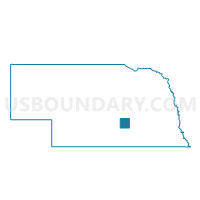
| Name | Doniphan Precinct |
| County | Hall County |
| State | Nebraska |
| Area (square miles) | 53.67 |
| Land Area (square miles) | 52.11 |
| Water Area (square miles) | 1.56 |
| % of Land Area | 97.09 |
| % of Water Area | 2.91 |
| Latitude of the Internal Point | 40.77769210 |
| Longtitude of the Internal Point | -98.32994490 |
Maps

Graphs
Select a template below for downloading or customizing gragh for Doniphan Precinct, Hall County, Nebraska


Neighbors
Neighoring Voting District (by Name) Neighboring Voting District on the Map
- #2 Precinct, Hamilton County, NE
- #5 Precinct, Hamilton County, NE
- Alda Precinct, Hall County, NE
- Martin/South Platte Precinct, Hall County, NE
- Vieregg Precinct, Merrick County, NE
- Washington One Precinct, Hall County, NE
- West Blue/Highland Precinct, Adams County, NE
Top 10 Neighboring County Subdivision (by Population) Neighboring County Subdivision on the Map
- Washington township, Hall County, NE (1,869)
- Doniphan township, Hall County, NE (1,099)
- Alda township, Hall County, NE (942)
- Vieregg township, Merrick County, NE (849)
- Precinct 5, Hamilton County, NE (824)
- South Platte township, Hall County, NE (799)
- Precinct 2, Hamilton County, NE (778)
- West Blue township, Adams County, NE (321)
Top 10 Neighboring Place (by Population) Neighboring Place on the Map
Top 10 Neighboring Unified School District (by Population) Neighboring Unified School District on the Map
- Aurora Public Schools, NE (6,666)
- Northwest Public Schools, NE (5,807)
- Doniphan-Trumbull Public Schools, NE (2,557)
- Giltner Public Schools, NE (682)
Top 10 Neighboring State Legislative District Upper Chamber (by Population) Neighboring State Legislative District Upper Chamber on the Map
Top 10 Neighboring 111th Congressional District (by Population) Neighboring 111th Congressional District on the Map
Top 10 Neighboring Census Tract (by Population) Neighboring Census Tract on the Map
- Census Tract 9654, Adams County, NE (4,169)
- Census Tract 11, Hall County, NE (4,082)
- Census Tract 13, Hall County, NE (2,885)
- Census Tract 9667, Merrick County, NE (2,615)
- Census Tract 9692, Hamilton County, NE (2,482)
Top 10 Neighboring 5-Digit ZIP Code Tabulation Area (by Population) Neighboring 5-Digit ZIP Code Tabulation Area on the Map
- 68801, NE (30,005)
- 68901, NE (26,354)
- 68803, NE (22,560)
- 68832, NE (1,974)
- 68865, NE (894)
- 68841, NE (610)
- 68980, NE (388)