


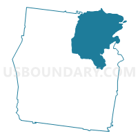
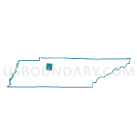
04-1 Jackson Chapel C.C. Voting District, Dickson County, Tennessee
About
Outline

Summary
| Unique Area Identifier | 668434 |
| Name | 04-1 Jackson Chapel C.C. Voting District |
| County | Dickson County |
| State | Tennessee |
| Area (square miles) | 81.62 |
| Land Area (square miles) | 80.65 |
| Water Area (square miles) | 0.98 |
| % of Land Area | 98.80 |
| % of Water Area | 1.20 |
| Latitude of the Internal Point | 36.24995280 |
| Longtitude of the Internal Point | -87.25686030 |
Maps

Graphs
Select a template below for downloading or customizing gragh for 04-1 Jackson Chapel C.C. Voting District, Dickson County, Tennessee


Neighbors
Neighoring Voting District (by Name) Neighboring Voting District on the Map
- 01-1 Charlotte CC Voting District, Dickson County, TN
- 03-1 Cumberland Fce Firehall Voting District, Dickson County, TN
- 05-1 William James Middle Voting District, Dickson County, TN
- 4-1 West Cheatham Elem. School Voting District, Cheatham County, TN
- 4-2 New Hope Community Center Voting District, Cheatham County, TN
- 4B Voting District, Montgomery County, TN
- 5-1 Two Rivers Fire Hall Voting District, Cheatham County, TN
Top 10 Neighboring County Subdivision (by Population) Neighboring County Subdivision on the Map
- District 4, Montgomery County, TN (6,941)
- District 4, Cheatham County, TN (6,604)
- District 5, Cheatham County, TN (6,115)
- District 5, Dickson County, TN (4,058)
- District 1, Dickson County, TN (3,986)
- District 3, Dickson County, TN (3,865)
- District 4, Dickson County, TN (3,821)
Top 10 Neighboring Place (by Population) Neighboring Place on the Map
Top 10 Neighboring Unified School District (by Population) Neighboring Unified School District on the Map
- Montgomery County School District, TN (166,179)
- Dickson County School District, TN (49,666)
- Cheatham County School District, TN (39,105)
Top 10 Neighboring State Legislative District Lower Chamber (by Population) Neighboring State Legislative District Lower Chamber on the Map
Top 10 Neighboring State Legislative District Upper Chamber (by Population) Neighboring State Legislative District Upper Chamber on the Map
Top 10 Neighboring 111th Congressional District (by Population) Neighboring 111th Congressional District on the Map
Top 10 Neighboring Census Tract (by Population) Neighboring Census Tract on the Map
- Census Tract 1017, Montgomery County, TN (8,091)
- Census Tract 602, Dickson County, TN (6,625)
- Census Tract 603, Dickson County, TN (6,376)
- Census Tract 702.02, Cheatham County, TN (5,179)
- Census Tract 701.02, Cheatham County, TN (4,243)
- Census Tract 601, Dickson County, TN (4,210)
- Census Tract 702.03, Cheatham County, TN (3,543)
- Census Tract 704.01, Cheatham County, TN (2,507)
Top 10 Neighboring 5-Digit ZIP Code Tabulation Area (by Population) Neighboring 5-Digit ZIP Code Tabulation Area on the Map
- 37043, TN (39,945)
- 37015, TN (17,184)
- 37187, TN (6,829)
- 37036, TN (5,862)
- 37035, TN (3,766)
- 37051, TN (3,677)
- 37171, TN (917)