


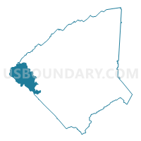
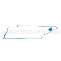
04 McDonald Voting District, Greene County, Tennessee
About
Outline

Summary
| Unique Area Identifier | 668577 |
| Name | 04 McDonald Voting District |
| County | Greene County |
| State | Tennessee |
| Area (square miles) | 32.45 |
| Land Area (square miles) | 32.12 |
| Water Area (square miles) | 0.33 |
| % of Land Area | 98.98 |
| % of Water Area | 1.02 |
| Latitude of the Internal Point | 36.14978760 |
| Longtitude of the Internal Point | -83.10406480 |
Maps

Graphs
Select a template below for downloading or customizing gragh for 04 McDonald Voting District, Greene County, Tennessee


Neighbors
Neighoring Voting District (by Name) Neighboring Voting District on the Map
- 03 Caney Branch Voting District, Greene County, TN
- 05 Orebank Voting District, Greene County, TN
- 06 Mohawk Voting District, Greene County, TN
- 10-1 Fish Hatchery Voting District, Hamblen County, TN
- 19 Midway Voting District, Greene County, TN
- Centerview Voting District, Cocke County, TN
- Forest Hill Voting District, Cocke County, TN
- Parrottsville Voting District, Cocke County, TN
Top 10 Neighboring County Subdivision (by Population) Neighboring County Subdivision on the Map
- District 6, Greene County, TN (9,848)
- District 5, Greene County, TN (7,228)
- District 2, Cocke County, TN (5,159)
- District 3, Cocke County, TN (5,071)
- District 10, Hamblen County, TN (4,636)
Top 10 Neighboring Unified School District (by Population) Neighboring Unified School District on the Map
- Hamblen County School District, TN (62,544)
- Greene County School District, TN (53,720)
- Cocke County School District, TN (28,717)
Top 10 Neighboring State Legislative District Lower Chamber (by Population) Neighboring State Legislative District Lower Chamber on the Map
Top 10 Neighboring State Legislative District Upper Chamber (by Population) Neighboring State Legislative District Upper Chamber on the Map
Top 10 Neighboring 111th Congressional District (by Population) Neighboring 111th Congressional District on the Map
Top 10 Neighboring Census Tract (by Population) Neighboring Census Tract on the Map
- Census Tract 1010, Hamblen County, TN (5,263)
- Census Tract 9203, Cocke County, TN (4,022)
- Census Tract 9201, Cocke County, TN (3,964)
- Census Tract 906, Greene County, TN (3,919)
- Census Tract 911, Greene County, TN (3,576)
- Census Tract 912, Greene County, TN (3,529)
Top 10 Neighboring 5-Digit ZIP Code Tabulation Area (by Population) Neighboring 5-Digit ZIP Code Tabulation Area on the Map
- 37743, TN (25,588)
- 37818, TN (4,998)
- 37860, TN (4,113)
- 37843, TN (3,725)
- 37809, TN (2,278)
- 37810, TN (1,928)
- 37713, TN (1,488)