


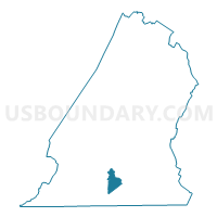
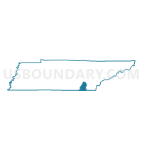
001 Airport 1 Voting District, Hamilton County, Tennessee
About
Outline

Summary
| Unique Area Identifier | 668633 |
| Name | 001 Airport 1 Voting District |
| County | Hamilton County |
| State | Tennessee |
| Area (square miles) | 5.13 |
| Land Area (square miles) | 5.13 |
| Water Area (square miles) | 0.00 |
| % of Land Area | 100.00 |
| % of Water Area | 0.00 |
| Latitude of the Internal Point | 35.04447750 |
| Longtitude of the Internal Point | -85.19665510 |
Maps

Graphs
Select a template below for downloading or customizing gragh for 001 Airport 1 Voting District, Hamilton County, Tennessee


Neighbors
Neighoring Voting District (by Name) Neighboring Voting District on the Map
- 006 Brainerd Voting District, Hamilton County, TN
- 007 Brainerd Hills Voting District, Hamilton County, TN
- 014 Dalewood Voting District, Hamilton County, TN
- 027 Kingsport Voting District, Hamilton County, TN
- 028 Lake Hills Voting District, Hamilton County, TN
- 046 Tyner 1 Voting District, Hamilton County, TN
- 049 Woodmore Voting District, Hamilton County, TN
- 095 Eastgate 2 Voting District, Hamilton County, TN
- 097 Tyner 2 Voting District, Hamilton County, TN
- 112 Airport 2 Voting District, Hamilton County, TN
- 141 Concord 3 Voting District, Hamilton County, TN
- 154 Airport 4 Voting District, Hamilton County, TN
Top 10 Neighboring County Subdivision (by Population) Neighboring County Subdivision on the Map
- District 7, Hamilton County, TN (40,838)
- District 8, Hamilton County, TN (36,110)
- District 5, Hamilton County, TN (33,358)
Top 10 Neighboring Place (by Population) Neighboring Place on the Map
Top 10 Neighboring Unified School District (by Population) Neighboring Unified School District on the Map
Top 10 Neighboring State Legislative District Lower Chamber (by Population) Neighboring State Legislative District Lower Chamber on the Map
- State House District 26, TN (64,600)
- State House District 30, TN (64,427)
- State House District 29, TN (58,580)
- State House District 28, TN (53,690)
Top 10 Neighboring State Legislative District Upper Chamber (by Population) Neighboring State Legislative District Upper Chamber on the Map
Top 10 Neighboring 111th Congressional District (by Population) Neighboring 111th Congressional District on the Map
Top 10 Neighboring Census Tract (by Population) Neighboring Census Tract on the Map
- Census Tract 33, Hamilton County, TN (6,477)
- Census Tract 114.43, Hamilton County, TN (5,664)
- Census Tract 123, Hamilton County, TN (4,609)
- Census Tract 34, Hamilton County, TN (4,343)
- Census Tract 114.44, Hamilton County, TN (3,813)
- Census Tract 114.45, Hamilton County, TN (3,704)
- Census Tract 30, Hamilton County, TN (2,380)
- Census Tract 9801, Hamilton County, TN (1)