


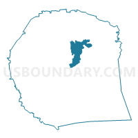
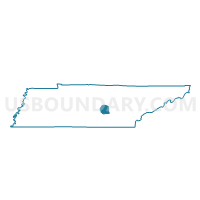
04-1 TSU Nursery Res. Center Voting District, Warren County, Tennessee
About
Outline

Summary
| Unique Area Identifier | 669894 |
| Name | 04-1 TSU Nursery Res. Center Voting District |
| County | Warren County |
| State | Tennessee |
| Area (square miles) | 9.95 |
| Land Area (square miles) | 9.93 |
| Water Area (square miles) | 0.02 |
| % of Land Area | 99.81 |
| % of Water Area | 0.19 |
| Latitude of the Internal Point | 35.73573600 |
| Longtitude of the Internal Point | -85.75187440 |
Maps

Graphs
Select a template below for downloading or customizing gragh for 04-1 TSU Nursery Res. Center Voting District, Warren County, Tennessee


Neighbors
Neighoring Voting District (by Name) Neighboring Voting District on the Map
- 01-1 McMinnville Civic Center Voting District, Warren County, TN
- 05-1 Three Star Mall Voting District, Warren County, TN
- 06-1 Warren Co. Middle School Voting District, Warren County, TN
- 07-1 East Side School Voting District, Warren County, TN
- 11-1 Midway Community Center Voting District, Warren County, TN
- 11-2 Hwy 56 N Church of Christ Voting District, Warren County, TN
Top 10 Neighboring County Subdivision (by Population) Neighboring County Subdivision on the Map
- District 1, Warren County, TN (3,527)
- District 4, Warren County, TN (3,521)
- District 11, Warren County, TN (3,161)
- District 7, Warren County, TN (3,161)
- District 6, Warren County, TN (2,962)
- District 5, Warren County, TN (2,925)
Top 10 Neighboring Place (by Population) Neighboring Place on the Map
Top 10 Neighboring Unified School District (by Population) Neighboring Unified School District on the Map
Top 10 Neighboring State Legislative District Lower Chamber (by Population) Neighboring State Legislative District Lower Chamber on the Map
Top 10 Neighboring State Legislative District Upper Chamber (by Population) Neighboring State Legislative District Upper Chamber on the Map
Top 10 Neighboring 111th Congressional District (by Population) Neighboring 111th Congressional District on the Map
Top 10 Neighboring Census Tract (by Population) Neighboring Census Tract on the Map
- Census Tract 9302, Warren County, TN (6,436)
- Census Tract 9304, Warren County, TN (6,013)
- Census Tract 9305, Warren County, TN (5,109)
- Census Tract 9306, Warren County, TN (3,708)
- Census Tract 9301, Warren County, TN (3,579)