


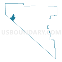
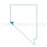
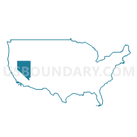
Precinct 41 - Daggett, Douglas County, Nevada
About
Outline

Summary
| Unique Area Identifier | 615267 |
| Name | Precinct 41 - Daggett |
| County | Douglas County |
| State | Nevada |
| Area (square miles) | 8.24 |
| Land Area (square miles) | 8.24 |
| Water Area (square miles) | 0.00 |
| % of Land Area | 100.00 |
| % of Water Area | 0.00 |
| Latitude of the Internal Point | 38.96275430 |
| Longtitude of the Internal Point | -119.90127620 |
Maps
Graphs
Select a template below for downloading or customizing gragh for Precinct 41 - Daggett, Douglas County, Nevada


Neighbors
Neighoring Voting District (by Name) Neighboring Voting District on the Map
- Voting District 50020, Alpine County, CA
- Voting District 50430, El Dorado County, CA
- Voting District 50445, El Dorado County, CA
- Precinct 29 - Autumn Hills, Douglas County, NV
- Precinct 38 - Round Hill, Douglas County, NV
- Precinct 39 - Edgewood, Douglas County, NV
- Precinct 40 - Kingsbury, Douglas County, NV
- Precinct 5 - Genoa, Douglas County, NV
Top 10 Neighboring County Subdivision (by Population) Neighboring County Subdivision on the Map
- South Lake Tahoe CCD, El Dorado County, CA (30,728)
- Zephyr Cove CCD, Douglas County, NV (5,402)
- Markleeville CCD, Alpine County, CA (1,175)
Top 10 Neighboring Place (by Population) Neighboring Place on the Map
- South Lake Tahoe city, CA (21,403)
- Kingsbury CDP, NV (2,152)
- Stateline CDP, NV (842)
- Round Hill Village CDP, NV (759)
Top 10 Neighboring Unified School District (by Population) Neighboring Unified School District on the Map
- Douglas County School District, NV (46,997)
- Lake Tahoe Unified School District, CA (29,839)
- Alpine County Unified School District, CA (1,175)
Top 10 Neighboring State Legislative District Lower Chamber (by Population) Neighboring State Legislative District Lower Chamber on the Map
Top 10 Neighboring State Legislative District Upper Chamber (by Population) Neighboring State Legislative District Upper Chamber on the Map
Top 10 Neighboring 111th Congressional District (by Population) Neighboring 111th Congressional District on the Map
- Congressional District 2, NV (836,562)
- Congressional District 3, CA (783,317)
- Congressional District 4, CA (774,261)
Top 10 Neighboring Census Tract (by Population) Neighboring Census Tract on the Map
- Census Tract 316, El Dorado County, CA (4,126)
- Census Tract 305.04, El Dorado County, CA (2,912)
- Census Tract 18, Douglas County, NV (2,152)
- Census Tract 13, Douglas County, NV (1,725)
- Census Tract 17, Douglas County, NV (1,601)
- Census Tract 19, Douglas County, NV (1,343)
- Census Tract 100, Alpine County, CA (1,175)
Top 10 Neighboring 5-Digit ZIP Code Tabulation Area (by Population) Neighboring 5-Digit ZIP Code Tabulation Area on the Map
- 96150, CA (29,792)
- 89460, NV (13,236)
- 89449, NV (2,994)
- 89448, NV (1,695)
- 96120, CA (957)
- 89411, NV (929)