


08 Niota School Voting District, McMinn County, Tennessee
About
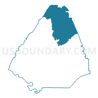
Outline

Summary
| Unique Area Identifier | 669120 |
| Name | 08 Niota School Voting District |
| County | McMinn County |
| State | Tennessee |
| Area (square miles) | 74.84 |
| Land Area (square miles) | 74.75 |
| Water Area (square miles) | 0.09 |
| % of Land Area | 99.89 |
| % of Water Area | 0.11 |
| Latitude of the Internal Point | 35.56077900 |
| Longtitude of the Internal Point | -84.56346150 |
Maps


Graphs
Select a template below for downloading or customizing gragh for 08 Niota School Voting District, McMinn County, Tennessee


Neighbors
Neighoring Voting District (by Name) Neighboring Voting District on the Map
- 01 Sweetwater High School Voting District, Monroe County, TN
- 02 Broad Street School Voting District, Monroe County, TN
- 04 Englewood School Voting District, McMinn County, TN
- 09 Ingleside School Voting District, McMinn County, TN
- 11 McMinn Courthouse Voting District, McMinn County, TN
- 12 North City School Voting District, McMinn County, TN
- 14 EK Baker School Voting District, McMinn County, TN
- 4 Meigs North Voting District, Meigs County, TN
- 5 Ten Mile Voting District, Meigs County, TN
- Johnson School House Voting District, Roane County, TN
- Luttrell Voting District, Loudon County, TN
Top 10 Neighboring County Subdivision (by Population) Neighboring County Subdivision on the Map
- District 1, Monroe County, TN (14,479)
- District 2, McMinn County, TN (11,398)
- District 1, McMinn County, TN (10,457)
- District 3, McMinn County, TN (9,759)
- District 7, Roane County, TN (7,326)
- District 4, Loudon County, TN (4,469)
- District 4, Meigs County, TN (2,074)
- District 5, Meigs County, TN (1,969)
Top 10 Neighboring Place (by Population) Neighboring Place on the Map
Top 10 Neighboring Elementary School District (by Population) Neighboring Elementary School District on the Map
Top 10 Neighboring Secondary School District (by Population) Neighboring Secondary School District on the Map
- McMinn County School District in Athens, TN (13,458)
- Monroe County School District in Sweetwater, TN (11,998)
Top 10 Neighboring Unified School District (by Population) Neighboring Unified School District on the Map
- Roane County School District, TN (51,122)
- Loudon County School District, TN (39,917)
- McMinn County School District, TN (35,318)
- Monroe County School District, TN (32,521)
- Meigs County School District, TN (11,753)
Top 10 Neighboring State Legislative District Lower Chamber (by Population) Neighboring State Legislative District Lower Chamber on the Map
- State House District 21, TN (73,052)
- State House District 22, TN (64,839)
- State House District 23, TN (64,022)
- State House District 32, TN (62,448)
Top 10 Neighboring State Legislative District Upper Chamber (by Population) Neighboring State Legislative District Upper Chamber on the Map
- State Senate District 5, TN (207,003)
- State Senate District 12, TN (188,880)
- State Senate District 9, TN (179,807)
Top 10 Neighboring 111th Congressional District (by Population) Neighboring 111th Congressional District on the Map
Top 10 Neighboring Census Tract (by Population) Neighboring Census Tract on the Map
- Census Tract 9251, Monroe County, TN (8,292)
- Census Tract 9253, Monroe County, TN (7,155)
- Census Tract 9701.01, McMinn County, TN (6,976)
- Census Tract 303, Roane County, TN (6,623)
- Census Tract 9701.02, McMinn County, TN (4,655)
- Census Tract 9252, Monroe County, TN (4,361)
- Census Tract 9705, McMinn County, TN (3,865)
- Census Tract 9704.01, McMinn County, TN (3,617)
- Census Tract 9703, McMinn County, TN (3,328)
- Census Tract 9601, Meigs County, TN (3,155)
Top 10 Neighboring 5-Digit ZIP Code Tabulation Area (by Population) Neighboring 5-Digit ZIP Code Tabulation Area on the Map
- 37303, TN (25,461)
- 37354, TN (16,483)
- 37874, TN (14,979)
- 37846, TN (5,030)
- 37826, TN (4,361)
- 37880, TN (3,477)