


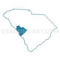
Aiken & Edgefield Counties--Aiken & North Augusta Cities PUMA, South Carolina
About
Outline

Summary
| Unique Area Identifier | 193939 |
| Name | Aiken & Edgefield Counties--Aiken & North Augusta Cities PUMA |
| State | South Carolina |
| Area (square miles) | 1,587.30 |
| Land Area (square miles) | 1,571.44 |
| Water Area (square miles) | 15.86 |
| % of Land Area | 99.00 |
| % of Water Area | 1.00 |
| Latitude of the Internal Point | 33.61320930 |
| Longtitude of the Internal Point | -81.73709140 |
Maps

Graphs
Select a template below for downloading or customizing gragh for Aiken & Edgefield Counties--Aiken & North Augusta Cities PUMA, South Carolina


Neighbors
Neighoring Public Use Microdata Area (by Name) Neighboring Public Use Microdata Area on the Map
- Central Savannah River Area Regional Commission (East Central)--Columbia County PUMA, GA
- Central Savannah River Area Regional Commission (East Central)--Richmond County PUMA, GA
- Central Savannah River Area Regional Commission (West & Outside Richmond & Columbia) PUMA, GA
- Greenwood, Abbeville & McCormick Counties PUMA, SC
- Lexington (South & West) & Saluda Counties--Lexington Town & Red Bank PUMA, SC
- Orangeburg, Colleton, Barnwell, Hampton, Bamberg & Allendale Counties PUMA, SC
Top 10 Neighboring County (by Population) Neighboring County on the Map
- Lexington County, SC (262,391)
- Richmond County, GA (200,549)
- Aiken County, SC (160,099)
- Columbia County, GA (124,053)
- Orangeburg County, SC (92,501)
- Greenwood County, SC (69,661)
- Edgefield County, SC (26,985)
- Burke County, GA (23,316)
- Barnwell County, SC (22,621)
- Saluda County, SC (19,875)
Top 10 Neighboring County Subdivision (by Population) Neighboring County Subdivision on the Map
- Augusta CCD, Richmond County, GA (134,777)
- Evans CCD, Columbia County, GA (86,553)
- Aiken CCD, Aiken County, SC (58,691)
- North Augusta CCD, Aiken County, SC (54,044)
- Pelion CCD, Lexington County, SC (24,185)
- Hephzibah CCD, Richmond County, GA (20,618)
- Gilbert CCD, Lexington County, SC (20,028)
- Swansea CCD, Lexington County, SC (16,186)
- New Ellenton CCD, Aiken County, SC (11,388)
- Southeast Edgefield CCD, Edgefield County, SC (9,276)
Top 10 Neighboring Place (by Population) Neighboring Place on the Map
- Augusta-Richmond County consolidated government (balance), GA (195,844)
- Aiken city, SC (29,524)
- Evans CDP, GA (29,011)
- North Augusta city, SC (21,348)
- Belvedere CDP, SC (5,792)
- Edgefield town, SC (4,750)
- Clearwater CDP, SC (4,370)
- Gloverville CDP, SC (2,831)
- Burnettown town, SC (2,673)
- Graniteville CDP, SC (2,614)
Top 10 Neighboring Unified School District (by Population) Neighboring Unified School District on the Map
- Richmond County School District, GA (200,549)
- Aiken County School District, SC (162,758)
- Columbia County School District, GA (124,053)
- Lexington School District 1, SC (121,030)
- Greenwood School District 50, SC (58,872)
- Edgefield County School District, SC (26,985)
- Burke County School District, GA (23,316)
- Orangeburg School District 4, SC (20,430)
- Lexington School District 4, SC (18,306)
- Saluda County School District, SC (15,200)
Top 10 Neighboring State Legislative District Lower Chamber (by Population) Neighboring State Legislative District Lower Chamber on the Map
- State House District 118, GA (60,824)
- State House District 123, GA (49,250)
- State House District 119, GA (46,117)
- State House District 122, GA (45,723)
- State House District 96, SC (41,272)
- State House District 121, GA (39,901)
- State House District 86, SC (39,715)
- State House District 84, SC (36,703)
- State House District 83, SC (36,663)
- State House District 81, SC (35,525)
Top 10 Neighboring State Legislative District Upper Chamber (by Population) Neighboring State Legislative District Upper Chamber on the Map
- State Senate District 24, GA (182,334)
- State Senate District 23, GA (153,242)
- State Senate District 22, GA (138,542)
- State Senate District 24, SC (99,070)
- State Senate District 25, SC (97,189)
- State Senate District 26, SC (91,335)
- State Senate District 40, SC (86,132)
- State Senate District 10, SC (84,695)
Top 10 Neighboring 111th Congressional District (by Population) Neighboring 111th Congressional District on the Map
- Congressional District 2, SC (825,324)
- Congressional District 10, GA (738,248)
- Congressional District 3, SC (722,675)
- Congressional District 12, GA (692,529)
Top 10 Neighboring Census Tract (by Population) Neighboring Census Tract on the Map
- Census Tract 301.02, Columbia County, GA (9,456)
- Census Tract 303.09, Columbia County, GA (8,986)
- Census Tract 212.03, Aiken County, SC (8,159)
- Census Tract 9702.02, Edgefield County, SC (7,439)
- Census Tract 216.02, Aiken County, SC (7,408)
- Census Tract 205, Aiken County, SC (7,150)
- Census Tract 220.02, Aiken County, SC (7,104)
- Census Tract 206.02, Aiken County, SC (6,214)
- Census Tract 219, Aiken County, SC (6,149)
- Census Tract 209.02, Aiken County, SC (5,994)
Top 10 Neighboring 5-Digit ZIP Code Tabulation Area (by Population) Neighboring 5-Digit ZIP Code Tabulation Area on the Map
- 30906, GA (57,748)
- 30907, GA (50,913)
- 30809, GA (38,168)
- 29803, SC (36,843)
- 29841, SC (32,494)
- 29801, SC (26,778)
- 30904, GA (25,666)
- 30901, GA (16,445)
- 29070, SC (15,330)
- 29860, SC (14,450)