


Voting District 44125, Los Angeles County, California
About
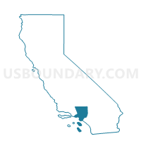
Outline

Summary
| Unique Area Identifier | 533476 |
| Name | Voting District 44125 |
| County | Los Angeles County |
| State | California |
| Area (square miles) | 0.01 |
| Land Area (square miles) | 0.01 |
| Water Area (square miles) | 0.01 |
| % of Land Area | 51.78 |
| % of Water Area | 48.22 |
| Latitude of the Internal Point | 33.89554620 |
| Longtitude of the Internal Point | -118.18726130 |
Maps


Graphs
Select a template below for downloading or customizing gragh for Voting District 44125, Los Angeles County, California


Neighbors
Neighoring Voting District (by Name) Neighboring Voting District on the Map
- Voting District 22520, Los Angeles County, CA
- Voting District 22523, Los Angeles County, CA
- Voting District 22526, Los Angeles County, CA
- Voting District 22529, Los Angeles County, CA
- Voting District 44119, Los Angeles County, CA
- Voting District 44122, Los Angeles County, CA
Top 10 Neighboring County Subdivision (by Population) Neighboring County Subdivision on the Map
Top 10 Neighboring Place (by Population) Neighboring Place on the Map
Top 10 Neighboring Unified School District (by Population) Neighboring Unified School District on the Map
Top 10 Neighboring State Legislative District Lower Chamber (by Population) Neighboring State Legislative District Lower Chamber on the Map
Top 10 Neighboring State Legislative District Upper Chamber (by Population) Neighboring State Legislative District Upper Chamber on the Map
Top 10 Neighboring 111th Congressional District (by Population) Neighboring 111th Congressional District on the Map
Top 10 Neighboring Census Tract (by Population) Neighboring Census Tract on the Map
- Census Tract 5537.02, Los Angeles County, CA (4,902)
- Census Tract 5421.04, Los Angeles County, CA (3,524)
- Census Tract 5421.06, Los Angeles County, CA (3,373)