


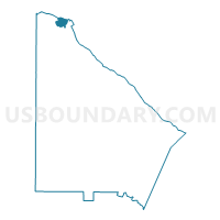
089KB - KINGSLEY ELEM Voting District, DeKalb County, Georgia
About
Outline

Summary
| Unique Area Identifier | 561206 |
| Name | 089KB - KINGSLEY ELEM Voting District |
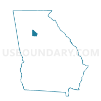
| County | DeKalb County |
| State | Georgia |
| Area (square miles) | 1.12 |
| Land Area (square miles) | 1.08 |
| Water Area (square miles) | 0.05 |
| % of Land Area | 95.84 |
| % of Water Area | 4.16 |
| Latitude of the Internal Point | 33.95200200 |
| Longtitude of the Internal Point | -84.29197170 |
Maps

Graphs
Select a template below for downloading or customizing gragh for 089KB - KINGSLEY ELEM Voting District, DeKalb County, Georgia


Neighbors
Neighoring Voting District (by Name) Neighboring Voting District on the Map
- 089DG - DUNWOODY HIGH SCHOOL Voting District, DeKalb County, GA
- 089MQ - MOUNT VERNON EAST Voting District, DeKalb County, GA
- 089TG - TILLY MILL ROAD Voting District, DeKalb County, GA
- 089WL - WINTERS CHAPEL Voting District, DeKalb County, GA
- 121SS01 - SS01 Voting District, Fulton County, GA
Top 10 Neighboring County Subdivision (by Population) Neighboring County Subdivision on the Map
Top 10 Neighboring Place (by Population) Neighboring Place on the Map
Top 10 Neighboring Unified School District (by Population) Neighboring Unified School District on the Map
Top 10 Neighboring State Legislative District Lower Chamber (by Population) Neighboring State Legislative District Lower Chamber on the Map
Top 10 Neighboring State Legislative District Upper Chamber (by Population) Neighboring State Legislative District Upper Chamber on the Map
Top 10 Neighboring 111th Congressional District (by Population) Neighboring 111th Congressional District on the Map
Top 10 Neighboring Census Tract (by Population) Neighboring Census Tract on the Map
- Census Tract 212.14, DeKalb County, GA (5,852)
- Census Tract 212.10, DeKalb County, GA (5,509)
- Census Tract 212.11, DeKalb County, GA (4,598)
- Census Tract 101.08, Fulton County, GA (3,830)