


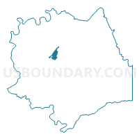
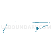
Maryville High School Voting District, Blount County, Tennessee
About
Outline

Summary
| Unique Area Identifier | 667988 |
| Name | Maryville High School Voting District |
| County | Blount County |
| State | Tennessee |
| Area (square miles) | 2.18 |
| Land Area (square miles) | 2.18 |
| Water Area (square miles) | 0.00 |
| % of Land Area | 100.00 |
| % of Water Area | 0.00 |
| Latitude of the Internal Point | 35.72623340 |
| Longtitude of the Internal Point | -83.98912140 |
Maps

Graphs
Select a template below for downloading or customizing gragh for Maryville High School Voting District, Blount County, Tennessee


Neighbors
Neighoring Voting District (by Name) Neighboring Voting District on the Map
- Fairview-City Voting District, Blount County, TN
- Fairview-County Voting District, Blount County, TN
- Maryville College Voting District, Blount County, TN
- Maryville Middle School Voting District, Blount County, TN
- Maryville Municipal-City Voting District, Blount County, TN
- Montvale Voting District, Blount County, TN
- William Blount Academy Voting District, Blount County, TN
- William Blount-City Voting District, Blount County, TN
Top 10 Neighboring County Subdivision (by Population) Neighboring County Subdivision on the Map
- District 4, Blount County, TN (18,310)
- District 6, Blount County, TN (14,548)
- District 5, Blount County, TN (10,767)
- District 1, Blount County, TN (10,476)
Top 10 Neighboring Place (by Population) Neighboring Place on the Map
Top 10 Neighboring Unified School District (by Population) Neighboring Unified School District on the Map
Top 10 Neighboring State Legislative District Lower Chamber (by Population) Neighboring State Legislative District Lower Chamber on the Map
Top 10 Neighboring State Legislative District Upper Chamber (by Population) Neighboring State Legislative District Upper Chamber on the Map
Top 10 Neighboring 111th Congressional District (by Population) Neighboring 111th Congressional District on the Map
Top 10 Neighboring Census Tract (by Population) Neighboring Census Tract on the Map
- Census Tract 111.02, Blount County, TN (8,743)
- Census Tract 112, Blount County, TN (7,915)
- Census Tract 106, Blount County, TN (4,243)
- Census Tract 105, Blount County, TN (2,700)