


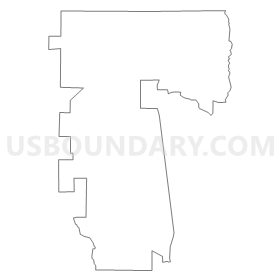
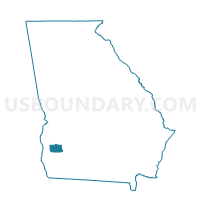
0374 - EDISON-ARLINGTON Voting District, Calhoun County, Georgia
About
Outline
Summary
| Unique Area Identifier | 560437 |
| Name | 0374 - EDISON-ARLINGTON Voting District |
| County | Calhoun County |
| State | Georgia |
| Area (square miles) | 71.15 |
| Land Area (square miles) | 70.78 |
| Water Area (square miles) | 0.37 |
| % of Land Area | 99.48 |
| % of Water Area | 0.52 |
| Latitude of the Internal Point | 31.54337110 |
| Longtitude of the Internal Point | -84.75265960 |
Maps

Graphs
Select a template below for downloading or customizing gragh for 0374 - EDISON-ARLINGTON Voting District, Calhoun County, Georgia


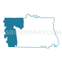
Neighbors
Neighoring Voting District (by Name) Neighboring Voting District on the Map
- 0372 - MORGAN Voting District, Calhoun County, GA
- 0373 - EDISON Voting District, Calhoun County, GA
- 0375 - ARLINGTON Voting District, Calhoun County, GA
- 0611 - BLUFFTON Voting District, Clay County, GA
- 099A - ARLINGTON Voting District, Early County, GA
- 099CO - COLOMOKEE Voting District, Early County, GA
- 243934 - CARNEGIE Voting District, Randolph County, GA
- 243947 - FOUNTAIN BRIDGE Voting District, Randolph County, GA
Top 10 Neighboring County Subdivision (by Population) Neighboring County Subdivision on the Map
- Blakely CCD, Early County, GA (7,728)
- Cuthbert CCD, Randolph County, GA (5,821)
- Morgan CCD, Calhoun County, GA (2,287)
- Edison CCD, Calhoun County, GA (2,221)
- Shellman CCD, Randolph County, GA (1,582)
- Damascus CCD, Early County, GA (1,438)
- Arlington CCD, Calhoun County, GA (1,310)
- Bluffton CCD, Clay County, GA (861)
Top 10 Neighboring Place (by Population) Neighboring Place on the Map
Top 10 Neighboring Unified School District (by Population) Neighboring Unified School District on the Map
- Early County School District, GA (11,008)
- Randolph County School District, GA (7,719)
- Calhoun County School District, GA (6,694)
- Clay County School District, GA (3,183)
Top 10 Neighboring State Legislative District Lower Chamber (by Population) Neighboring State Legislative District Lower Chamber on the Map
Top 10 Neighboring State Legislative District Upper Chamber (by Population) Neighboring State Legislative District Upper Chamber on the Map
Top 10 Neighboring 111th Congressional District (by Population) Neighboring 111th Congressional District on the Map
Top 10 Neighboring Census Tract (by Population) Neighboring Census Tract on the Map
- Census Tract 7902, Randolph County, GA (5,821)
- Census Tract 9502, Calhoun County, GA (3,531)
- Census Tract 9603, Clay County, GA (3,183)
- Census Tract 9501, Calhoun County, GA (3,163)
- Census Tract 902, Early County, GA (2,670)
- Census Tract 7901, Randolph County, GA (1,898)
- Census Tract 901, Early County, GA (1,438)
Top 10 Neighboring 5-Digit ZIP Code Tabulation Area (by Population) Neighboring 5-Digit ZIP Code Tabulation Area on the Map
- 39823, GA (8,550)
- 39840, GA (5,726)
- 39846, GA (2,440)
- 39866, GA (2,122)
- 39813, GA (2,110)
- 39886, GA (1,616)
- 39824, GA (544)
- 39836, GA (461)