


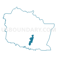
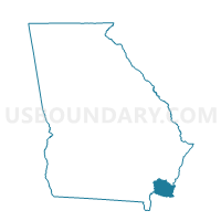
03913 - MUSH BLUFF Voting District, Camden County, Georgia
About
Outline

Summary
| Unique Area Identifier | 560446 |
| Name | 03913 - MUSH BLUFF Voting District |
| County | Camden County |
| State | Georgia |
| Area (square miles) | 11.55 |
| Land Area (square miles) | 10.23 |
| Water Area (square miles) | 1.32 |
| % of Land Area | 88.57 |
| % of Water Area | 11.43 |
| Latitude of the Internal Point | 30.81696040 |
| Longtitude of the Internal Point | -81.59042130 |
Maps

Graphs
Select a template below for downloading or customizing gragh for 03913 - MUSH BLUFF Voting District, Camden County, Georgia


Neighbors
Neighoring Voting District (by Name) Neighboring Voting District on the Map
- 03905 - HARRIETTS BLUFF Voting District, Camden County, GA
- 03909 - GROSS ROAD Voting District, Camden County, GA
- 03910 - NORTH SAINT MARY Voting District, Camden County, GA
- 03911 - MARY LEE CLARK Voting District, Camden County, GA
- 03914 - WEST SAINT MARY Voting District, Camden County, GA
Top 10 Neighboring County Subdivision (by Population) Neighboring County Subdivision on the Map
Top 10 Neighboring Place (by Population) Neighboring Place on the Map
Top 10 Neighboring Unified School District (by Population) Neighboring Unified School District on the Map
Top 10 Neighboring State Legislative District Lower Chamber (by Population) Neighboring State Legislative District Lower Chamber on the Map
Top 10 Neighboring State Legislative District Upper Chamber (by Population) Neighboring State Legislative District Upper Chamber on the Map
Top 10 Neighboring 111th Congressional District (by Population) Neighboring 111th Congressional District on the Map
Top 10 Neighboring Census Tract (by Population) Neighboring Census Tract on the Map
- Census Tract 104.01, Camden County, GA (10,563)
- Census Tract 104.02, Camden County, GA (5,417)
- Census Tract 102, Camden County, GA (5,108)
- Census Tract 104.03, Camden County, GA (3,828)
- Census Tract 105, Camden County, GA (2,757)