


001-Kampville Voting District, St. Charles County, Missouri
About
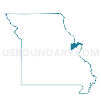
Outline

Summary
| Unique Area Identifier | 609640 |
| Name | 001-Kampville Voting District |
| County | St. Charles County |
| State | Missouri |
| Area (square miles) | 18.82 |
| Land Area (square miles) | 17.77 |
| Water Area (square miles) | 1.05 |
| % of Land Area | 94.43 |
| % of Water Area | 5.57 |
| Latitude of the Internal Point | 38.84554620 |
| Longtitude of the Internal Point | -90.52033410 |
Maps


Graphs
Select a template below for downloading or customizing gragh for 001-Kampville Voting District, St. Charles County, Missouri


Neighbors
Neighoring Voting District (by Name) Neighboring Voting District on the Map
- 004-Orchard Farm Voting District, St. Charles County, MO
- 005-Rivers Voting District, St. Charles County, MO
- 021-Truman Voting District, St. Charles County, MO
- 034-McNair Voting District, St. Charles County, MO
- 043-Marina Voting District, St. Charles County, MO
- 045-Mamelle Voting District, St. Charles County, MO
- 054-Coverdell Voting District, St. Charles County, MO
- 056-Edgewood Voting District, St. Charles County, MO
- 057-Hanover Voting District, St. Charles County, MO
- 063-St. Andrews Voting District, St. Charles County, MO
- 107-Oak Creek Voting District, St. Charles County, MO
- 122-Mid Rivers Voting District, St. Charles County, MO
- NW009 Voting District, St. Louis County, MO
- NW027 Voting District, St. Louis County, MO
- NW044 Voting District, St. Louis County, MO
- NW046 Voting District, St. Louis County, MO
- POINT Voting District, Calhoun County, IL
Top 10 Neighboring County Subdivision (by Population) Neighboring County Subdivision on the Map
- Northwest township, St. Louis County, MO (32,245)
- Rivers township, St. Charles County, MO (22,257)
- Zumbehl township, St. Charles County, MO (20,336)
- Lindenwood township, St. Charles County, MO (19,602)
- Point precinct, Calhoun County, IL (1,066)
Top 10 Neighboring Place (by Population) Neighboring Place on the Map
- St. Charles city, MO (65,794)
- St. Peters city, MO (52,575)
- Hazelwood city, MO (25,703)
- Bridgeton city, MO (11,550)
Top 10 Neighboring Unified School District (by Population) Neighboring Unified School District on the Map
- Hazelwood School District, MO (118,853)
- Fort Zumwalt R-II School District, MO (110,048)
- St. Charles R-VI School District, MO (53,421)
- St. Charles County R-V School District, MO (10,607)
- Brussels Community Unit School District 42, IL (1,337)
Top 10 Neighboring State Legislative District Lower Chamber (by Population) Neighboring State Legislative District Lower Chamber on the Map
- State House District 97, IL (103,784)
- State House District 17, MO (43,513)
- State House District 15, MO (40,041)
- State House District 18, MO (32,967)
- State House District 78, MO (30,572)
Top 10 Neighboring State Legislative District Upper Chamber (by Population) Neighboring State Legislative District Upper Chamber on the Map
- State Senate District 49, IL (207,061)
- State Senate District 23, MO (170,166)
- State Senate District 7, MO (160,542)
Top 10 Neighboring 111th Congressional District (by Population) Neighboring 111th Congressional District on the Map
- Congressional District 2, MO (706,622)
- Congressional District 17, IL (634,792)
- Congressional District 1, MO (587,069)
Top 10 Neighboring Census Tract (by Population) Neighboring Census Tract on the Map
- Census Tract 3106.02, St. Charles County, MO (5,787)
- Census Tract 3108.02, St. Charles County, MO (5,775)
- Census Tract 2114.01, St. Louis County, MO (5,329)
- Census Tract 2113.34, St. Louis County, MO (4,111)
- Census Tract 3102.02, St. Charles County, MO (3,747)
- Census Tract 3102.01, St. Charles County, MO (2,679)
- Census Tract 9513, Calhoun County, IL (2,408)
- Census Tract 3101, St. Charles County, MO (2,342)
- Census Tract 3108.01, St. Charles County, MO (2,187)
- Census Tract 3115, St. Charles County, MO (1,905)